One last hurrah. Today is the final day of our epic journey. The big adios. One final transcendent day in the saddle with a long route that will undoubtedly land among your all-time best rides. The early jitters are long gone and you’re well in the groove. But now that the finish line is in sight, everything becomes a little more memorable. So savor every last climb and drink in every last descent. As you forge ahead, take a minute or two to look back at how far we’ve come. The friends you’ve made, the challenges you’ve met, and the communities you’ve helped support. All in a week’s vacation.
Day 7: Dayville to John Day
Short Route: 31.6 miles / 1,404′ elevation
Main Route: 61.7 miles / 4,699’ elevation
Maybe your cup is full and you want a simple close to the week. If so, the Short Route for Day 7 is straightforward. One right turn, pedal for a bit, one left turn, done! You’ll twist and turn with the John Day River and arrive back in John Day with time to see some interesting historical sights and grab a meal before, *sigh*, going back to real life.
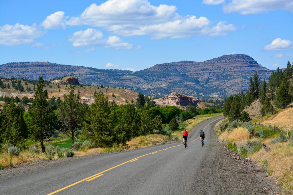
Maybe we’ll call Day 7’s Main Route the “Big Dipper” because it has a slight resemblance to the constellation and it scoops up all sorts of wonderous sights and riding experiences along the way. This route has it all and what better way to end this amazing Cycle Oregon Classic than a route like this! Get warmed up as you roll east along the John Day Highway because your first scoop into the dipper is the climb up Fields Creek Road. Fields Peak and the Aldrich Mountains are to your left and if you could look over the peak you’d see down into John Day. But first, a beautiful long ride along NF-21 with just a dash of gravel thrown in. We did say this route had everything! A rest stop and a water stop bookend the high-elevation riding here and shortly after that final bottle refill you’ve summited the final climb of the day and ladle out over 2000′ of descending on the ride back to John Day. Big Chainring + Big Views = Perfect Finish to a fantastic 32nd edition of Cycle Oregon Classic.
John Day, Oregon (pop. 1665) is named after the nearby John Day River. The river is named after John Day, a Virginian assigned to an 1811 expedition to Astoria who, by historical accounts, despite doing many legendary things never actually set foot in the location that now bears his name.
In the late 1800’s John Day was home to a large Chinese community and The Kam Wah Chung Company Building on NW Canton Street is a near perfectly preserved Chinese herbal apothecary and mercantile from the era. The historical time capsule and interpretive center, a Bicycle Friendly Business, is an example of the special places that Cycle Oregon Signature & Community Grants preserve and protect. Travel Oregon says of this State Heritage Site, “If you haven’t seen this place, you need to go.” We agree. Stick around town for a bit and enjoy everything the John Day community has to offer.
View all Classic XXXII routes on Ride with GPS here
Geology Rocks! by Ian Madin
Ian Madin worked as a geologist with the Oregon Department of Geology and Mineral Industries for 32 years and has ridden with Cycle Oregon for over a decade now. Here, he gives us a look at the the cool and sometimes hidden geology of the regions through which we ride. His nightly presentations at Classic are always fun and informative so grab a cold beverage or dessert (maybe both!) and grab a seat when we get him on the mic.
Be sure to read Ian’s Classic XXXII Geology Rocks! preview feature first. You can find it on our blog here.
About the Route Classic XXXII Day 1 is here.
About the Route Classic XXXII Day 2 is here.
About the Route Classic XXXII Day 3 is here.
About the Route Classic XXXII Day 4 is here.
About the Route Classic XXXII Day 5 is here.
About the Route Classic XXXII Day 6 is here.
The Easy Way or the Hard Way – Your last day riding through the varied and spectacular scenery and geology of the Painted Hills region offers you a choice between an easy way and a hard way. It is probably no surprise that the geologic choice is either very simple or very complicated.

For those that take the gentle route up the John Day Valley along Highway 26, the geology will recede into the background. The topography is gentle, the rocks rarely visible, and there are no longer big transitions across unconformities. Most of the route passes either Mascall Formation sediment layers, or the even younger Rattlesnake Formation. You encountered the Rattlesnake Tuff on Day 1 just outside Mt. Vernon, but you are unlikely to see the tuff exposed along this stretch. The Rattlesnake tuff in this region is just one layer within a series of layers of sand and gravel deposited by rivers before and after the cataclysmic Rattlesnake eruption. On the north side of the valley, the Rattlesnake and Mascall layers are tilted towards the south, which makes them susceptible to large landslides. When weak layers within a body of rock are tilted so that they slope downhill. It is much easier for the overlying body of rock to slide. About 1.5 miles from Dayville you will pass a large slide on the left side of the highway. This mass of jumbled Mascall and Rattlesnake sediments is a mile from head to toe and over half a mile wide.

About 6.75 mile east of Dayville, the road enters a short narrow gorge. This is the result of a large landslide on the south side of the valley that has pushed the river up against Columbia River Basalt on the north bank. This makes for a great exposure of a Columbia River Basalt flow top in the roadcuts on your left. You will see a horizontal band of bright red rubbly lava rock separating two layers of columnar basalt. The red layer is the top of the underlying flow. As the flow moves, the top part repeatedly freezes and fractures, building up a layer of broken basalt rubble. The next layer flowed across the rubble zone as a lake of liquid lava, and the heat baked the underlying flow top, causing the iron in the rock to oxidize bright red.

Just past Fields Creek Road, where the long route turns off, there is a great roadcut which shows more Columbia River Basalt which has been tilted so steeply by movement on a nearby fault that the layers are nearly vertical.

For those who choose the long route, the geologic story gets complicated quickly. Immediately upon leaving the Highway, the road passes through a mile-thick block of Columbia River Basalt that has been turned on edge by faulting. Then things get really messy. You will now be passing quickly across the unconformity between the Basalt and the John Day/Clarno, but within another mile or so will pass across the third unconformity that you encountered near Mitchell, entering into a large region of exotic rocks. Like the small patch of marble and blueschist near Mitchell, these rocks formed 200 million years ago out in the Pacific Ocean, and were smashed onto the edge of North America in a violent collision about 150 million years ago. As a result, the majority of the long route is a complicated mixture of rocks. There is sandstone, conglomerate and mudstone, lava, serpentine and large areas of a rock called mélange. Melange forms in tectonic collision zones where many different bodies of rock become broken and intermixed. The fragments in a mélange come in all sizes, and the types of rock can vary dramatically. So this is a good place to just enjoy the ride and think about the enormous amount of time and distance these rocks have traveled to get to where they are today.
As you make your final descent down Highway 395 into Canyon City, headed for that sandwich and beer at the finish line, keep your eyes peeled for two more types of rock in the roadcuts. You will pass some areas of coarse gravel packed high on the site of the canyon, which are remnants of gold-bearing gravel terraces that were mined during the 1800s. You will also pass some roadcuts of beautiful shiny green and black serpentine.

Thank you to all involved for helping support our community here in Grant county!