Day 5 is our second option-packed layover day of the week and there are adventures galore! Allow Cycle Oregon to be your activity directors – tell us what sounds fun to you and we’ll help you do it. Mitchell is the ideal home base for taking off on an ambitious 69-mile ride, exploring the world-famous Painted Hills, checking out an incredibly choice section of gravel, or pitching in on a community service project with the good people of Mitchell. Or do it all. Or do none of the above! Totally up to you. And that, friends, is the beauty of Day 5!

Day 5: Mitchell Layover
Short Route: 17.9 miles / 929′ elevation
Main Route: 68.8 miles / 6,937’ elevation
GRAVEL Option: 41.6 miles / 3,163′ elevation
Another day in Mitchell and we’re giving you the full day to enjoy the splendor of the Painted Hills Unit of the John Day Fossil Beds National Monument. It’s called one of the 7 Wonders of Oregon and if you’ve not seen them in real life today will be a day you remember forever.
Today’s Short Route, an 18-mile round trip ride with only 900′ of elevation, is all about enjoying the Painted Hills. The destination (and turnaround point) is the Painted Hills Overlook Trail; this is the iconic viewpoint you’ve seen in photos but now it’s real and it’s spectacular. There are five trails in the Unit, each with a unique geologic personality from over 30-million years ago. The Painted Hills are alive with yellows, golds, blacks, and reds and are beautiful at all times of the day though the late afternoon is best for dramatic photography.
If that’s all the riding you want to do today we can’t blame you one bit but if you’ve got the giddy up to get up and go for more we’ve have two exciting route options. Day 5’s Main Route offers a richly challenging ride with a familiar feel. You’ll ride back through Twickenham and Gird Creek (we came down this way on Day 4) but with a different point of view and a different pace. This all-pavement day is a great way to add to your elevation totals and earn bragging rights. Bragging? Nah, we just do it for the extra desserts!
Day 5’s GRAVEL Option just might be the Goldilocks route of the week. Not too long, not too short, just enough climbing and a 60/40 split of pavement/gravel. The sugar sprinkled on the porridge here is that we’ll take you to the Painted Hills Overlook Trail about three-quarters of the way through. And you’ll roll up to the viewpoint with a wild smile on your face because Bridge Creek Road is what the cycling gods had in mind when they created gravel. The twists, turns and undulations offer a range of views of Bridge Creek and Lockwood Canyon that recall the wild, wild West. Best of all, hidden away in the hillsides and roadside are miniature geologic exposures that reveal glorious colors, tiny windows into the expansive past. Enjoy the finish on a serpentine paved road and roll into camp where everything will be “just right” for a night of relaxing under the stars.
Please remember, #Don’tHurtTheDirt – stay on trails and no collecting.
Geology Rocks! by Ian Madin
Ian Madin worked as a geologist with the Oregon Department of Geology and Mineral Industries for 32 years and has ridden with Cycle Oregon for over a decade now. Here, he gives us a look at the the cool and sometimes hidden geology of the regions through which we ride. His nightly presentations at Classic are always fun and informative so grab a cold beverage or dessert (maybe both!) and grab a seat when we get him on the mic.
Be sure to read Ian’s Classic XXXII Geology Rocks! preview feature first. You can find it on our blog here.
About the Route Classic XXXII Day 1 is here.
About the Route Classic XXXII Day 2 is here.
About the Route Classic XXXII Day 3 is here.
About the Route Classic XXXII Day 4 is here.
View all Classic XXXII routes on Ride with GPS here
Painting the Hills Red – The short ride to the Painted Hills unit of the John Day Fossil Beds National Monument (JDFBNM) is one of the most rewarding you can take. Although the Painted Hills unit is quite small, it is full of sublime beauty underlain by a unique convergence of geologic features.

Leaving Mitchell, the route enters a narrow gorge for the last mile before Burnt Ranch Road takes you off the highway. Here you once again cross the second unconformity, between the older conglomerate and mudstone and the John Day/Clarno rocks. For the first half of the gorge, Gable Creek conglomerate layers alternate with much weaker mudstone, forming a series of bold ribs of hard rock. Once you cross the unconformity, Clarno basalt flows are capped with thick paleosols, again forming resistant ribs alternating with the softer soils.
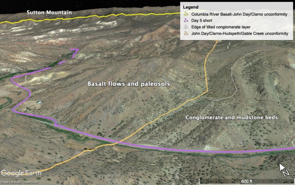
Leaving the highway, Burnt Ranch Road runs down a broad valley eroded by Bridge Creek out of soft John Day ash and paleosols. You will begin to see areas of tan or white exposed sediment, then suddenly around the corner, a smoothly rounded hill of bright red. To your right, the skyline is dominated by Sutton Mountain, the thick block of Columbia River Basalt you rode through yesterday ascending Girds Creek Road. As you proceed down the creek, you will pass the mouth of Meyers Canyon on your right. The spectacular gully you passed yesterday begins just a quarter mile up the canyon from here and extends over 4 miles. The valley continues to open out as you near the Painted Hills, and you will start to see brilliantly colored badlands carved in John Day ash layers on both sides of the roads. The geo-scenery gets more spectacular as you proceed, culminating in the overlook in the Painted Hills unit, a short mile of gravel road beyond the Painted Hills information center.
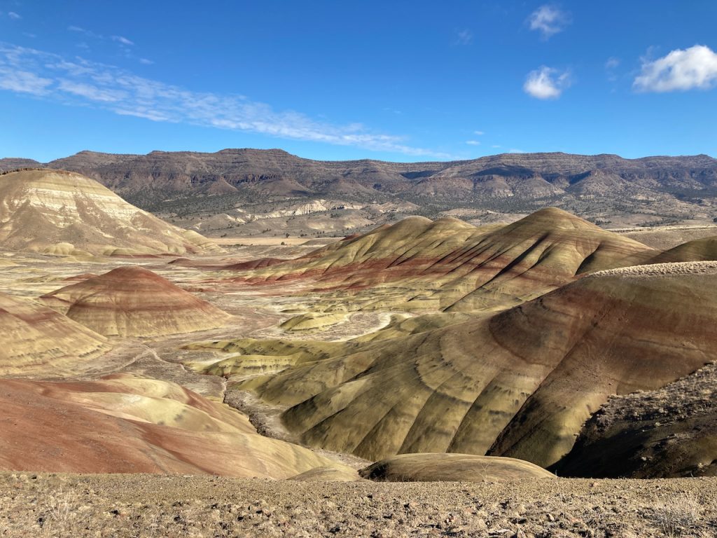
Make sure to take some time to look over the interpretive material at the small visitor center near the entrance, and at the overlook. It is definitely worth the short stretch of gravel from the entrance to the overlook to get the best views.
The smooth rounded hills here with their brilliant red, cream and yellow colors are the result of a rare combination of factors. The rocks themselves are more ash and fine sediment of the John Day Formation, similar to areas we have seen every other day of the ride. The colored layers are paleosols, which mark long periods of stability during which the warm wet climate turned the ash layers to clay and stained the ground with iron oxides. The paleosols themselves aren’t unusual, as we have seen similar colored layers before. The slopes here are completely barren of vegetation, which allows us to see the intricate layers and colors, but we have passed areas of bare rock badlands on previous days. This is one of the few places where the ash layers, paleosols and barren ground come together in an erosion environment that leave gracefully curving smooth slopes. You can see colored ash in the hills to the west and north, largely covered by vegetation. You can see bare slopes of ash and sediment to the east at the base of Sutton Mountain, but there the landscape is eroded into ragged badlands. A perfect combination of geology, climate and topography makes this place special.
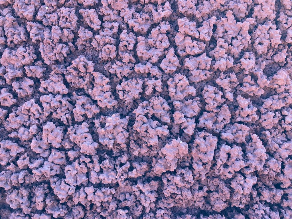
The volcanic ash in the Painted Hills has been weathered and chemically altered over millions of years, turning what was originally a mass of fine shards of glass and mineral crystals into a mass of bentonite clay. Bentonite has some unusual characteristics, including the ability to absorb large amounts of water and turn into a gelatinous mass. This is not great if you are trying to ride or drive on a wet dirt road made of bentonite, but it is great if you are trying to capture moisture, so bentonite is the primary ingredient in clay-based kitty litter. The tendency of bentonite to swell into a sticky mass when saturated probably helps prevent erosion of the Painted Hills slopes. When the clay dries out it leaves a crumbly soil broken by a network of shrinkage cracks.

For those taking the gravel route, the first half of the ride retraces the last half of the Day 4 route, until Twickenham, where it follows the John Day River downstream a few miles before turning back up the Bridge Creek valley. You will circle around the west end of Sutton Mountain, as the unconformity and the Columbia River Basalt climb steadily up the side of Sutton Mountain. You will see little glimpses of red, blue-green and white John Day ash in roadcuts, up gullies and in small barren patches on some slopes, increasing as you approach the Painted Hills.
For those taking the long route, the geology from Mile 1 to Mile 34 is covered in the Day 4 blog, from mile 34 to mile 43.2 in the last part of the Day 2 blog, and from 43.2 to 57.8 is covered in the beginning of the Day 6 blog.