Ian Madin has worked as a geologist with the Oregon Department of Geology and Mineral Industries for nearly 30 years. In his spare time he enjoys riding with Cycle Oregon and sharing stories about the incredibly cool geology of Oregon.
Day 1: Greens and Glaciers

On Day 1, we will be riding through the poorly exposed volcanic rocks of the Western Cascades as we ascend the North Fork of the Middle Fork of the Willamette. We will start out riding in a deep, steep green canyon, like Brice Creek or Canton Creek on later days, but about the time we get to our snack stop at Kiahane Campground, the terrain will change dramatically, as we enter a wide valley with a flat bottom. This valley, and the upper reaches of the South Fork of the McKenzie, have both been carved out by glaciers descending from the High Cascades (figure 1). In Figure 1, you can clearly see the broad “U” shape that is characteristic of glacial valleys.
Day 2: Fire and Ice

On our second day we will travel through some of the most dramatic and dynamic geology in Oregon, and the scenery isn’t half bad either. The good news is that you will be riding slowly and steadily uphill through most of the best geology and scenery, so you will have plenty of time to take it in.
Before we leave Rainbow, you should walk down to the McKenzie River at least once. You will be amazed by the clarity of the water, and we will see similar crystal waters in the upper reaches of the North Umpqua. Many of the Rivers flowing out of the High Cascades have this beautifully clear water. Most of the rocks in the High Cascades are lava flows of various types, but almost all are very porous and very permeable. Porous means that there is a lot of space for water in fractures and openings in the rock, permeable means that those spaces are connected, and water can easily flow through. As a result, much of the heavy snow and rain that falls here every year simply percolates into the ground and fills a giant volcanic sponge instead of running off across the surface. The water travels through the rocks to emerge in large springs which feed rivers like the North Santiam, McKenzie, North Umpqua, Deschutes and Metolius. Lost Creek and the White Branch both disappear into the porous lava for many miles. If you have time on your way home, take a hike along the McKenzie near the Blue Pool, or stop at Clear Lake at the head of the McKenzie and hike over to the Big Springs that feed the lake.

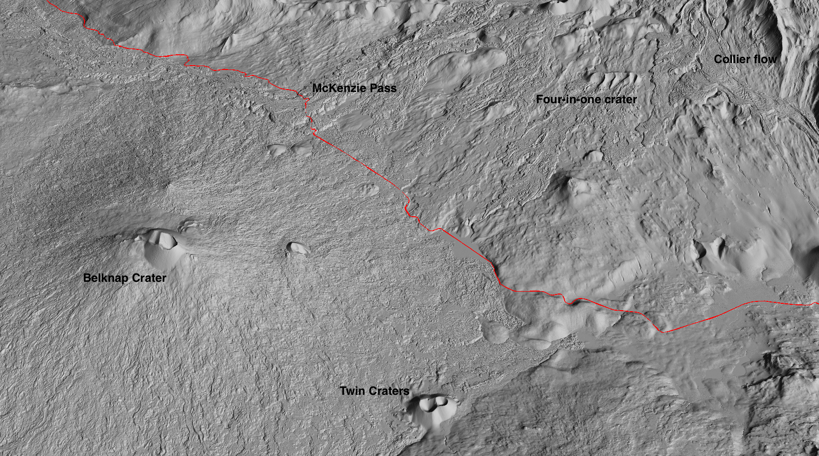
On our way up McKenzie Pass, (Figure 2) we ride past glacial valleys and moraines, dozens of active faults, cinder cones and lava flows only a few thousand years old, all under the shadow of some of the most spectacular High Cascade Volcanoes. The landscape is shaped by the powerful forces of volcanism and glaciation interacting in the very recent past.
20,000 years ago, most of the highlands along the route were completely covered by an ice cap, and the White Branch and nearby valleys filled with thick glaciers. What remains are glacial moraines, glacier scoured lava flows, and deep “U” shaped glacial valleys. In Figure 3, you can see the classic “U”-shaped profile of the glacial valley; steep straight valley walls and broad flat valley floor. Most of the high plateau above the valley consists of pre-glacial (but still very young) lava flows that were scraped and scoured by the flow of ice across them. This leaves a surface that is not as rough and chaotic as the fresh lava flows, but still retains a very irregular surface, typically dotted with small meadows, ponds and lakes. Although we will not be able to see them from the road, we will be passing an incredible set of glacial moraines as we ride up the White Branch. Rock debris gets incorporated into flowing ice, and where the ices melts away along the glacier front and edges, the debris accumulates into piles called moraines. On the south wall of the White Branch valley, and in the highlands on either side, there are beautifully preserved sets of nested moraines, which appear as sets of parallel linear ridges. These record a progressive decline in the extent of ice, with each moraine formed during a period of relative stability, followed by a new and lower moraine after the ice has receded a bit and temporarily stabilized. These types of nested moraines only form when the ice is retreating, if the ice advances, it obliterates all earlier moraines.

The highlands on either side of the White Branch glacial valley are sliced by dozens of active faults. These features were completely unsuspected until they were revealed by lidar collected in 2016. The faults run north south, and must have moved recently, because they cut across moraines that formed during the last glaciation, which ended 20,000 years ago. The most spectacular of these faults creates a 45-foot high wall across the landscape. Geologists have just begun to study these faults to learn their history, but they are some of the most impressive in Oregon.

Shortly after our morning snack stop, we will encounter the snout of the Collier Cone lava flow. Collier Cone is a cinder cone on the north flank of the North Sister that produced several fluid lava flows 1500 years ago. One flow found its way into the head of the White Branch and cascaded down into the valley, partly filling the upper reaches. From the road it will appear as a huge wall of lava rubble on your right, and there is a very short hike that will take you on to the surface of the flow, but to really see the cool features, we need to look at the lidar image in Figure 4. The flow has many short lobes, that look rather like molten wax flowing off a candle. It also has pronounced levees along the edges. These are formed when the rate of flow decreases, and the fluid lava drains away from the frozen edges. Sets of nested levees show that there were numerous pulses of lava. Linton Lake, across the flow from the highway, was formed when the flow blocked a side valley.
At the top of the switchbacks we will pass Sims Butte, a post-glacial cinder cone, and after a few miles we will enter a stretch of lava barrens that extend all the way to the top of the pass at the Dee Wright Observatory. These young lava flows came from Belknap Crater to the left, and from Four in One, Yapoah and Collier cones to the right. Most of these flows erupted about 1,500 years ago and their rough, rubbly surfaces have changed little since then. This is a very hostile environment for vegetation because there is no soil so that snowmelt and rainfall disappear into the porous lava, leaving little to support trees or shrubs.
The highway through the lava fields provides excellent views of the North and Middle Sisters to the south. The North Sister (10,085 ft) was built by eruptions between 45,000 and 140,000 years ago, while the Middle Sister(10,047 ft) is only 20,000 to 25,000 years old. Both are heavily eroded by glaciers, but the glaciers are rapidly retreating, and may soon disappear altogether as our climate warms.  The Collier Glacier, which occupies the north side of the North Sister, extended nearly to Collier Cone in the early 1900’s. It has retreated about a mile since then. To the north you will see Mt. Washington (7,790 ft), the eroded stump of an older volcano, and Mt. Jefferson (10,496 ft) which was largely built over the last 100,000 years, with the most recent eruptions 15,000 years ago.
Day 3: The Young and the Restless
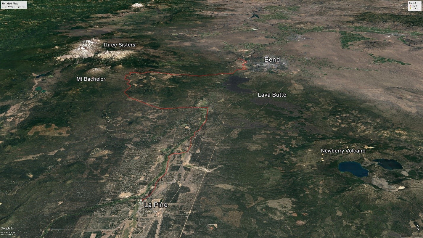
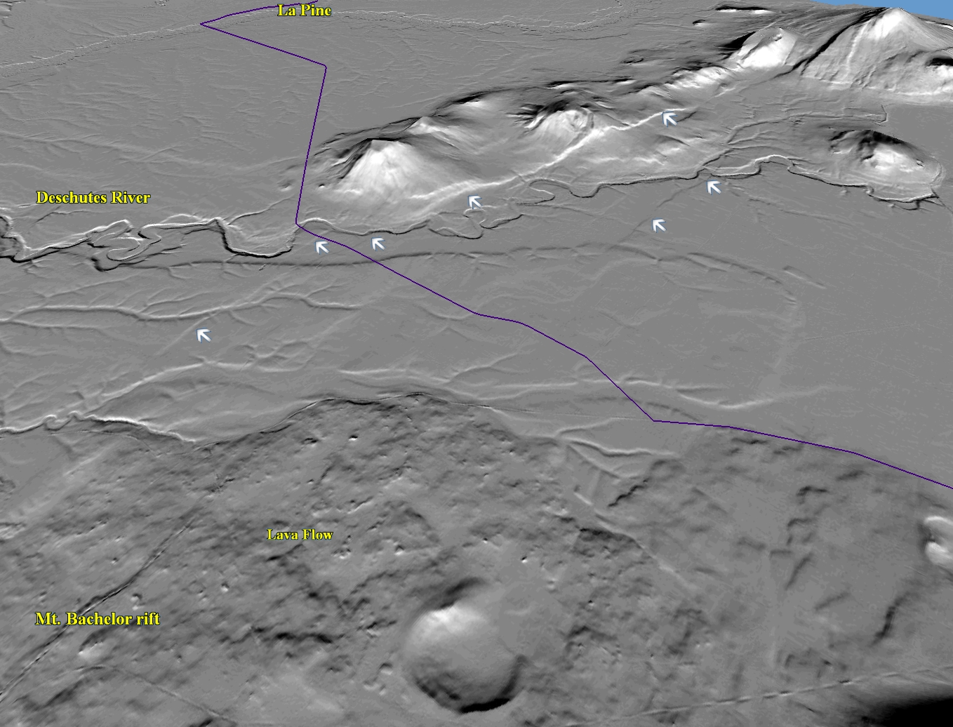
Our ride today starts in the sagebrush and Juniper forests of the central Oregon high desert. For the first dozen miles we will skirt the western edge of Bend, across a broad plateau that slopes gently to the east and is interrupted by small canyons coming down from the High Cascades to our west. This plateau is made of a mix of river sediment, glacial deposits and lava flowing off the Cascades. Under these young rocks are older layers of volcanic ash and pumice. The terrain is subdued, so we won’t see much in the way of rocks. We also won’t see a series of faults underneath our tires (Figure 2). Although they won’t be obvious when we cross them, these faults show up as straight steps in the land surface that run for miles across the plateau. Part of the Tumalo fault zone, they have probably been active in the last 10,000 to 20,000 years, and may pose a significant seismic threat to Bend and nearby communities.

Pumice was mined at several sites along this part of the route, but the mines have been closed and in many cases reclaimed for suburban development. Most pumice is used for making lightweight concrete, like the familiar cinder block.

We will turn west and begin the climb up the Cascade lakes Highway towards the High Cascades and Mt. Bachelor. The forest will start to change to huge, red-barked Ponderosa pines as we climb, which eventually give way to scrawny lodgepole pines as we near Mt. Bachelor. We will get great view of Mt. Bachelor as we ride, though at this time of year it may be a dull brown cone with only a few hints of the snow cover that makes it such a great winter sport destination. Mt. Bachelor is a 9,068 ft high stratovolcano, composed of layers of volcanic cinder and lava. The mountains original cone shape is well preserved, because it was formed about 9,500 years ago, after the last major glaciation, and has seen little glacial erosion. The eruptions that formed Mt. Bachelor were part of a larger rift eruption; a series of volcanic vents that formed along a 15 mile-long fault. If we strip away the forest with lidar imagery (Figure 3) you can easily see the dozens of small cinder cones that make up this chain of craters. These eruptions build cinder cones by spraying fluid lava in the air, which freezes into small bits and falls back to pile up in a cone. More fluid lava wells up out of the rift and flows across the landscape, leaving intricate multi-lobed flows.
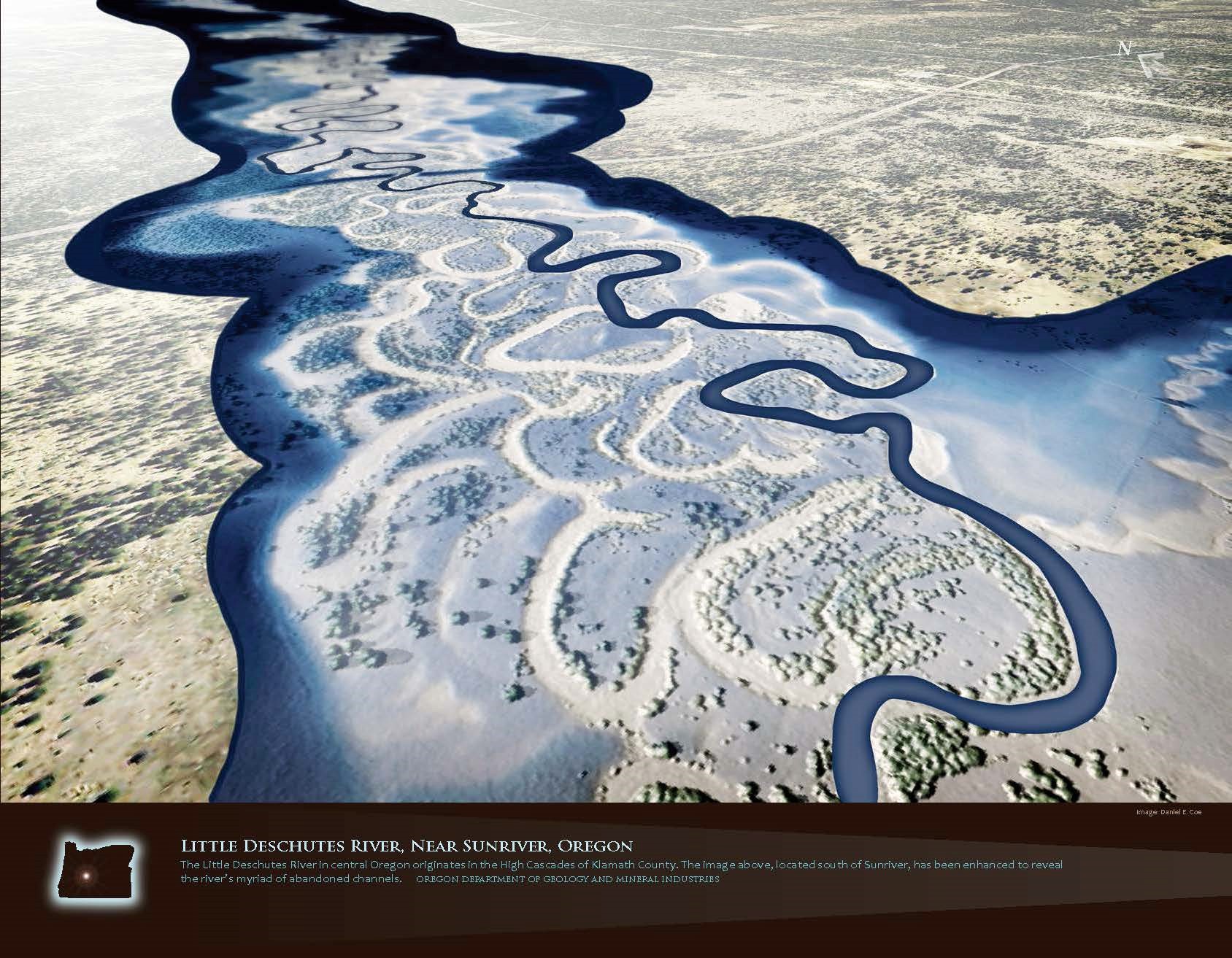
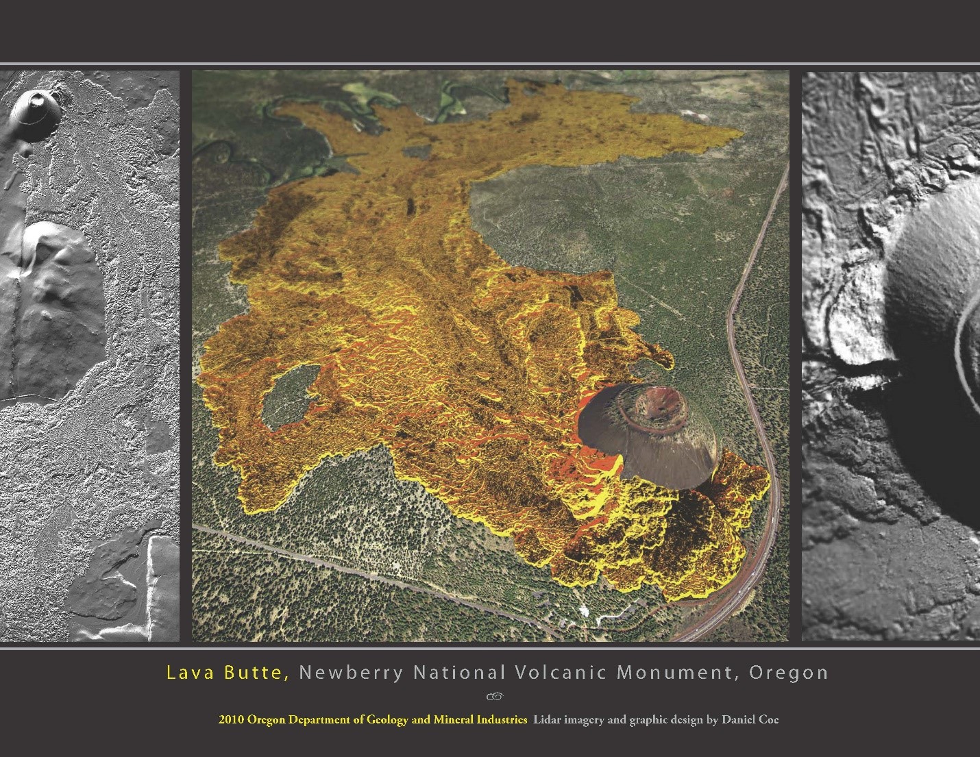
After we turn onto Forest Road 45 we will descend along the edge of the young flows from the Bachelor rift, but the forest will obscure most of the geology. We will see a nice cinder cone on our right shortly after we make the turn. As we arrive in the Sunriver area, we will cross the Deschutes River and then turn right to ride up the Little Deschutes River. The climb will be very gentle, because the valley here is very flat, as a result, the rivers form contorted looping meanders (Figure 4). The reason that the valley floor here is so flat is that 6,000 years ago, an eruption at Lava Butte (Figure 5) blocked the Deschutes river, forming a series of falls and cascades, and causing the valley upstream to fill in with sediment, which in turn made the rivers meander. The cinder cone at the vent for the Lava Butte flow has a great visitor center and opportunities for hikes around the cone and flow.
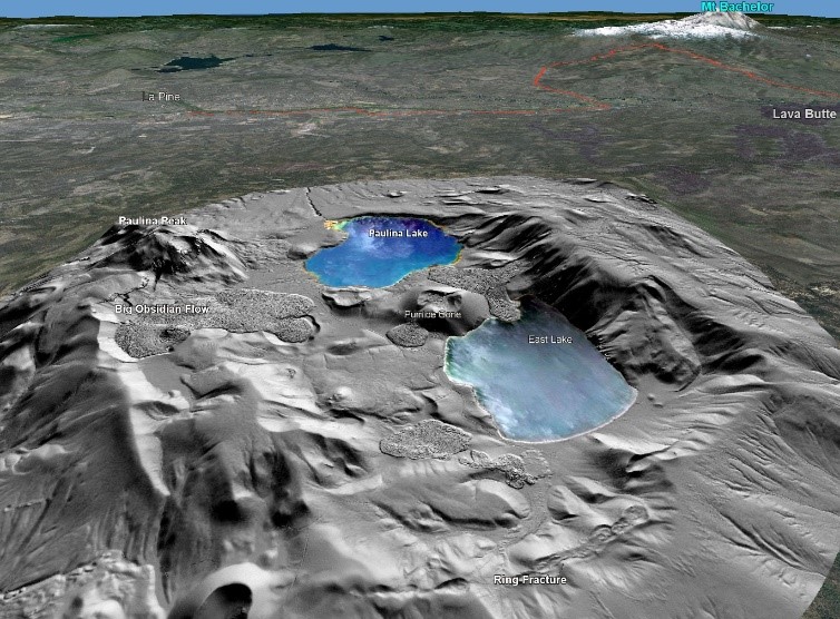
As we ride up the Little Deschutes River to La Pine, the low forested mountain on our left is Newberry Volcano. Newberry is the largest active volcano in the Cascades, but has a very different character than the more familiar snow capped cones like Mt. Bachelor or Mt. Hood. Mt. Hood rises 7000 feet above the surrounding terrain, and has a footprint of about 75 square miles; Newberry stands only 3,400 feet above the surrounding terrain, but covers an area of over 500 square miles. Newberry is a shield volcano, which is formed by eruptions of very fluid basalt lava. The lava flows so easily that it spreads our rapidly and doesn’t build a steep cone like most of the Cascade volcanoes. One lava flow from Newberry traveled over 40 miles to reach the Crooked River north of Bend.
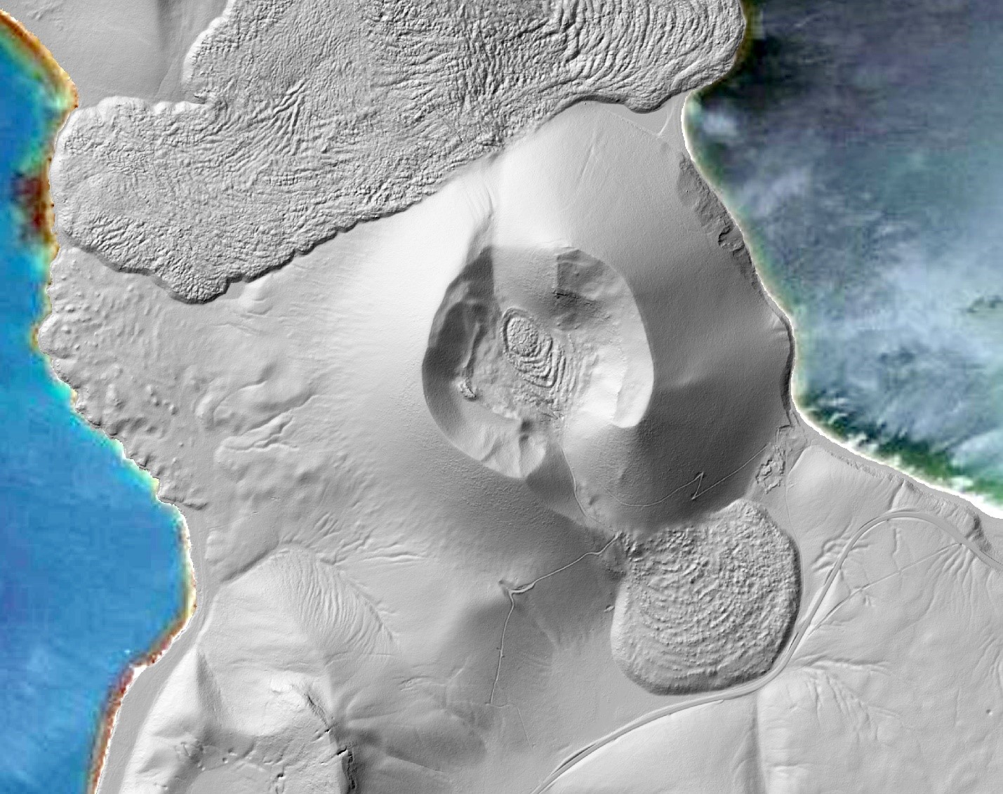
The caldera of Newberry volcano is a fascinating place (Figure 6) and is worth a visit on a future trip (the ride up into the caldera is a great climb). The caldera formed in explosive eruptions about 75,000 years ago, and is filled with two beautiful lakes and many cool volcanic features. The Big Obsidian Flow erupted only 1,300 years ago, and the central Pumice Cone (Figure 7) looks like something out of Mordor. The floor of the caldera is littered with steam explosion pits formed by the heat from the magma that lies near the surface, and both lakes have hot springs in their beds. An exploratory geothermal well in the caldera encountered temperatures of 500 degrees at a depth of 3000 feet, and exploration for geothermal energy continues today on the flanks of the volcano.
Day 4: Lava and Lakes

Today’s ride takes us through part of the Cascades Lakes region before settling in for some long straight slogs down Highway 97 and west to Diamond Lake. Like Day 3, the area we are riding through has a huge concentration of young volcanoes, ranging in size from a cinder cone a few hundred feet across to the 9,000-ft high cone of Mt. Bachelor (Figure 1). In fact, on Day 3 we passed within five miles of 124 young volcanoes, and today we will pass another 101. These volcanoes come in a wide variety shapes and sizes and erupt a wide range of materials; lava, cinders, pumice and ash. The way in which a volcano erupts depends on the chemical composition of the molten rock, or magma, that is rising to the surface. Most volcanic rocks contain iron, aluminum, magnesium, sodium, calcium, titanium, and loads of silica, a compound made up of silicon and oxygen. Although silica is always the most abundant material in volcanic rocks, the amount varies quite a bit. At one end of the range is basalt, which is about half silica. Because of the low silica, basalt erupts at nearly 2,200 degrees F and is very fluid. Rhyolite, at the other end of the range is nearly three quarters silica, and is relatively cool (about 1,200 F) and very stiff and sticky when it erupts. This difference in the fluidity of lava makes all the difference in how it erupts.
All magma contains dissolved gasses like water vapor, carbon dioxide and sulfur dioxide. As magma rises near the surface, this highly compressed gas begins to bubble out of the magma. If the magma is basalt, the lava is so fluid when it reaches the surface that the gasses easily escape, often casting spectacular lava fountains. The fountain lava freezes in the air into small bits, called cinders, which rain down and build a cone around the vent. When there is less gas, the basalt lava flows freely away from the vent, behaving almost like water as it flows for many miles. If the magma is rhyolite, huge pressure can build up in the lava as it reached the surface with the gas still trapped in the sticky molten rock. That often leads to spectacular explosions, as all of the gas suddenly expands, ripping the lava body to shreds and blowing it miles in the sky. The gas bubbles in the hot lava expand as the fragments fly through the air, and then freeze into pumice. Magma that falls between these two extremes has a range of eruption styles and we will see many along the way.
As we leave La Pine and head west, we will cross another series of active faults (Figure 2) about 10 miles into the day. This group is part of the La Pine graben, which is a geologic structure that is formed when an area of land subsides between sets of parallel faults, and occurs when the landscape is being stretched. We will also pass by the southern end of the Mt. Bachelor rift, which probably extends beneath our route but is buried by young sediments deposited by the Deschutes River.
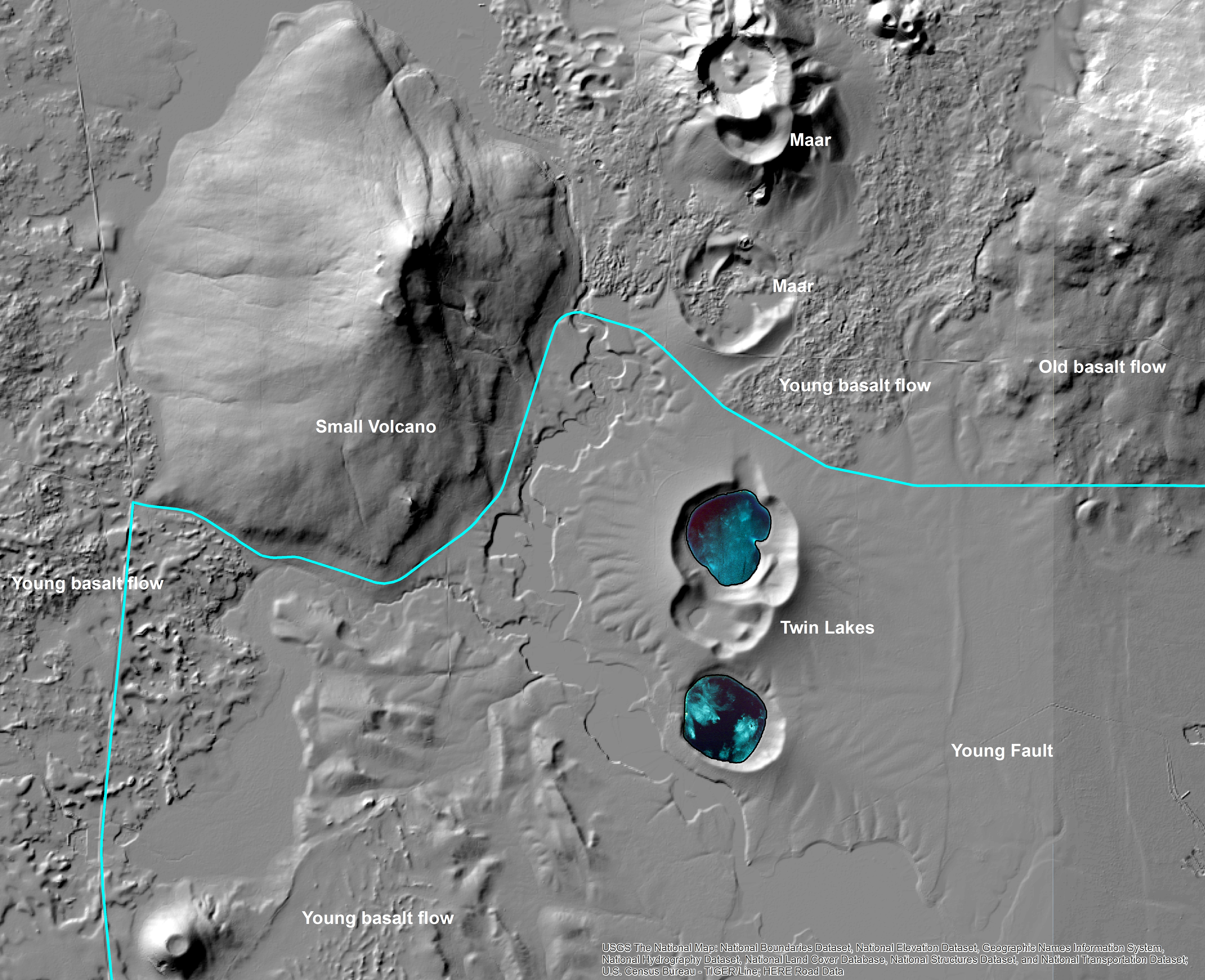
We will make a big turn to the south near the Twin Lakes, which have an unusual origin. Natural lakes almost always point to very young and active geology. Lakes fill up with sediment rapidly, so it typically takes some sort of very powerful or rapid geologic process to create one that we see today. Most natural lakes in Oregon were formed when glaciers dug holes in bedrock, or left dams of glacial rubble. The Twin Lakes (Figure 3) have a much more exciting and unusual origin. They are maars, which are volcanic vents that form when rapidly rising magma encounters groundwater very close to the surface. The intense heat causes the water to flash into steam, producing an explosion and leaving behind a crater that fills with water.

As we turn south past the Twin Lakes, we will cross the Deschutes River, and then in a few miles we will cross over Odell Creek. If you look to the right as you cross the bridge, you will notice that the creek seems to end abruptly at a wall of dark gray lava. This is the Davis Lake andesite flow which erupted about 5,000 years ago. Andesite is a lava type that is intermediate between basalt and rhyolite. In this case the lava flowed, but was sticky enough that it built up in a series of lobes right around the vent (Figure 4). The lava flows slowly enough that a crust of solid rock several feet thick develops, which is then broken as the molten material beneath continues to move. This type of lava flow is called an aa flow, and leaves the surface of the flow a chaotic jumble of sharp jagged blocks. Much of the surface of the flow is still bare lava, and in the last 5,000 years vegetation has only found a foothold on the smoother surfaces of cinder cones near the center. Walking across the surface of an aa flow is very difficult and hazardous. Don’t try in your bike shoes!
We will ride along the edge of the flow, and arrive at Davis Lake, which is another example of a volcanic lake. In this case the lava flow blocked Odell creek forming a huge natural dam. An aa flow is typically very porous, so the lake actually drains through the flow, emerging on the north side as a large spring.
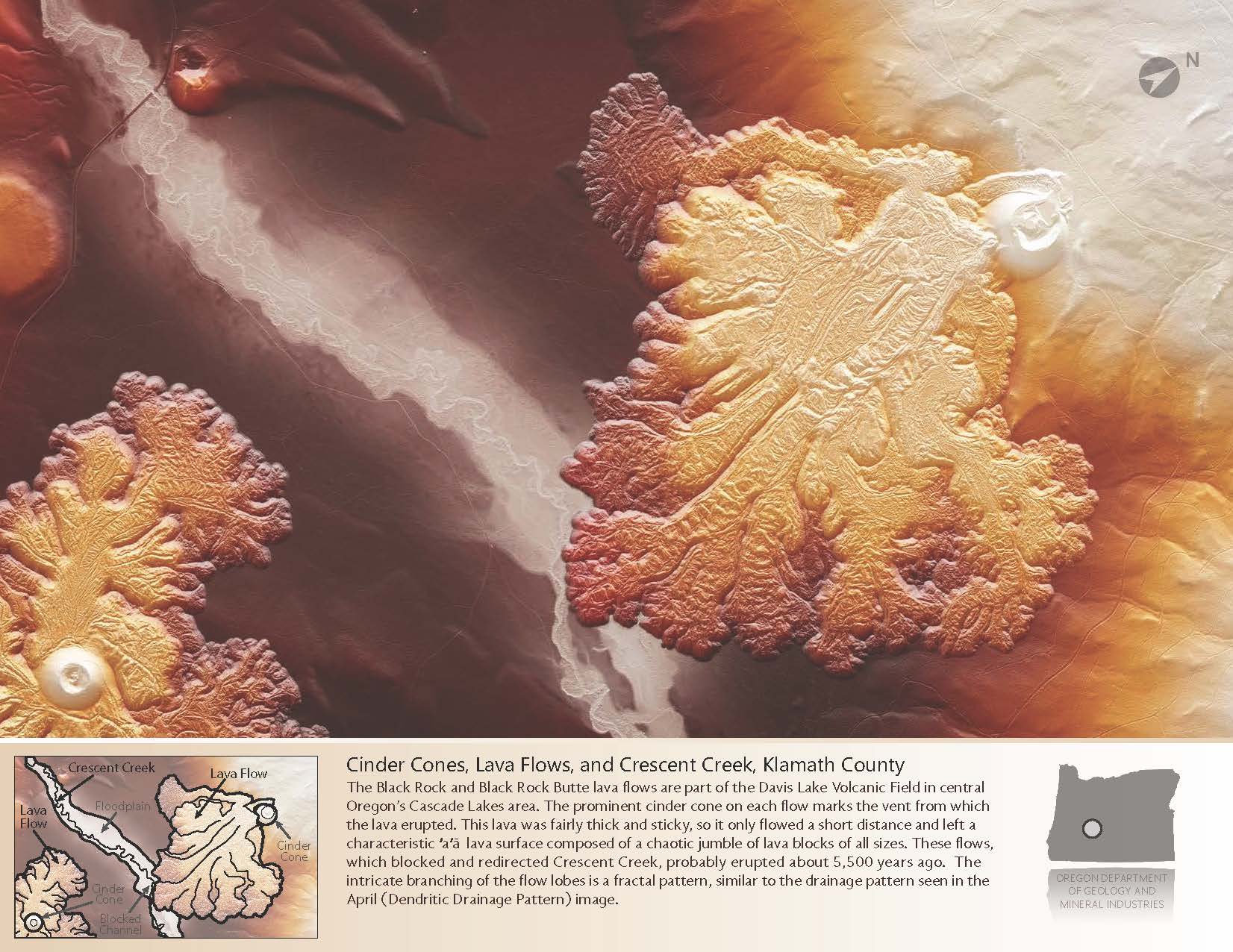
About 8 miles past Davis Lake we may see another young lava flow about a mile to our left, and then another mile along we will pass right by a similar flow. Both of these lava flows, the Black Rock and Black Rock Butte flow, are also about 5,000 years old.
We soon reach Highway 97 and turn south, and from here the geology is much harder to see. The landscape is very flat and forested, and affords few views. As we leave Chemult we will pass a roadcut 10-20 ft high in which you will see bright white rock fragments of many sizes. This is pumice that came from an explosive rhyolite-type eruption about 7,700 years ago. You will continue to see this white pumice material, sometimes yellowish, from here all the way to camp.
About 1.5 miles after we turn onto Highway 138 and begin the long, slow climb up to the pass, you may see a small red cone off to your right. This is one of many small basalt cinder cones in the area. These cones are a common source of gravel and sand that is used to spread on the highways in icy conditions. The cinders are usually loose and easy to dig, and can be easily crushed or separated into the right size for road sanding. Enjoy the sight, because the next 10 miles are one of the longest and most monotonous straightaways you will ever see.
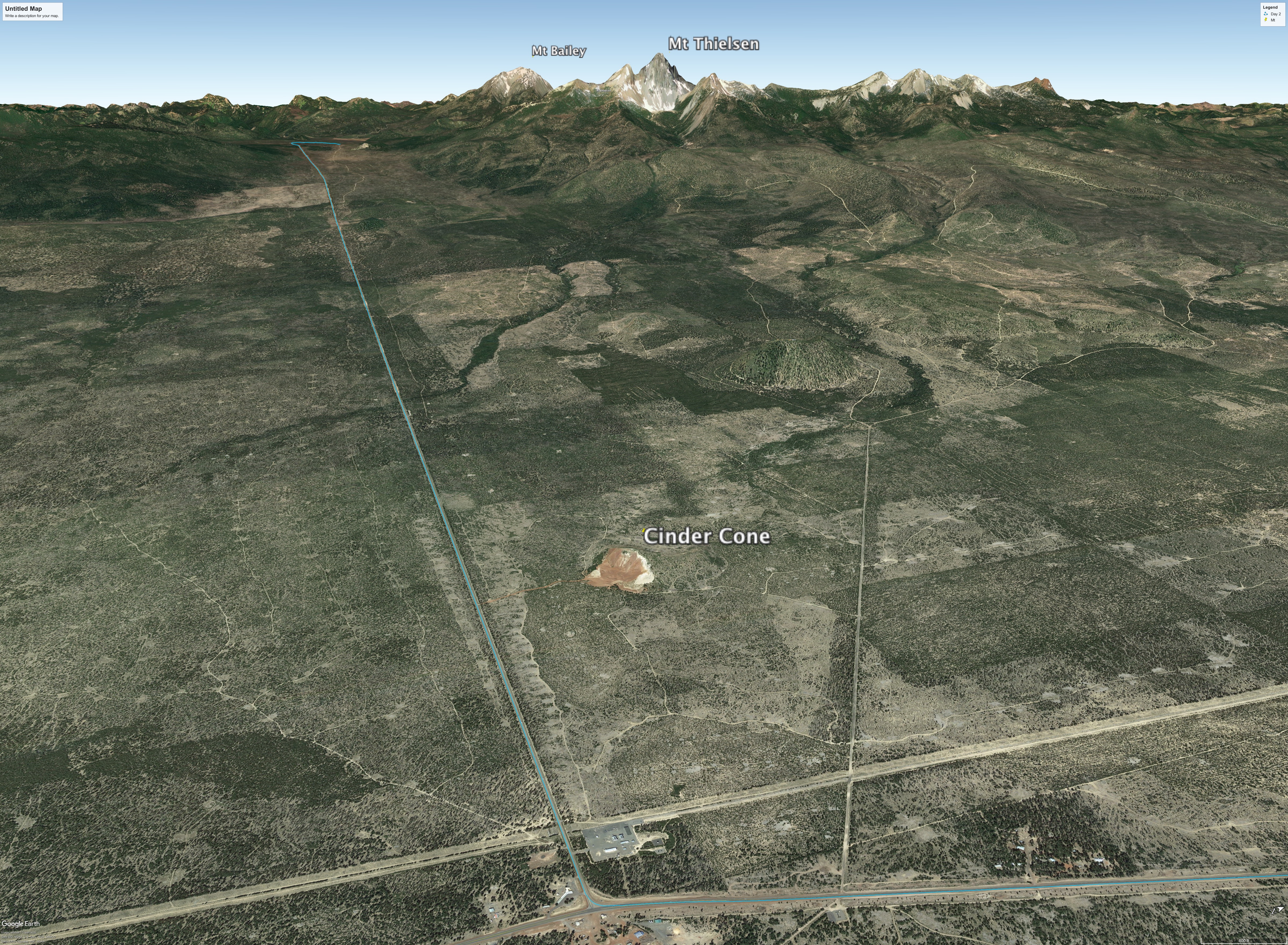
As we near the pass, you may be able to see Mt. Thielsen on your right through the trees. This is another major Cascade volcano that is 9,184 ft high. Eruptive activity ceased here about 250,000 years ago, and what must once have been a very impressive mountain has been ground to a sharp point by several periods of glaciation.
Day 5: Crater Lake, a Geological Jewel

Today you can choose a leisurely ride through the forest around Diamond Lake or a strenuous ride around the spectacular Crater Lake (or I suppose some of you will do both). Either way you are in for a great day!
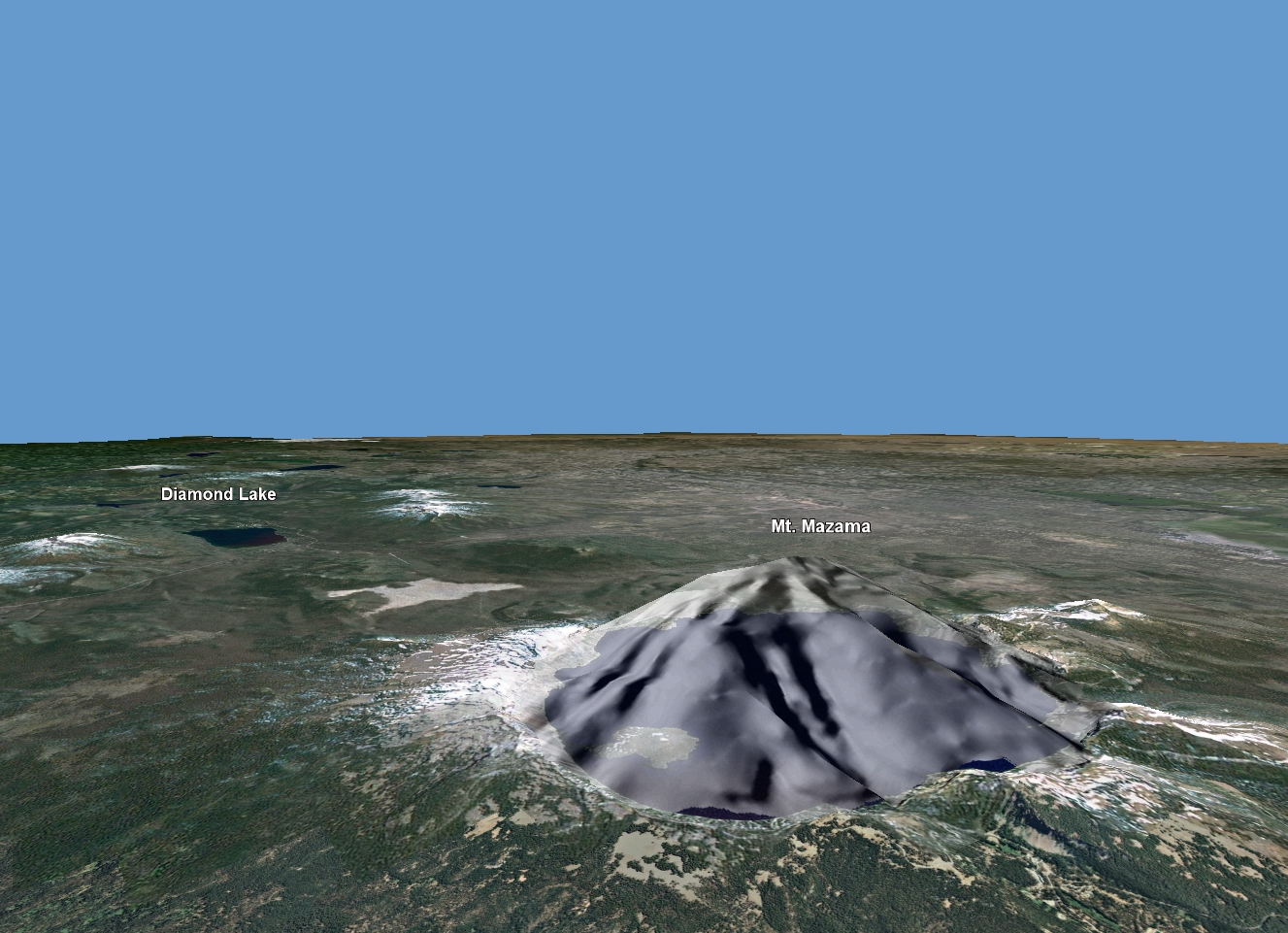
Crater Lake formed during a cataclysmic eruption of Mt. Mazama, one of about a dozen large active volcanoes in the Cascade chain. Mt.Mazama had a long eruptive history, and probably looked like Mt. Hood or Mt. Rainier; a snow-capped cone carved by deep glacial valleys. Simply projecting the lower slopes of the mountain upwards suggests that Mt. Mazama was 12,000 to 14,000 feet tall (Figure 2).
About 7,700 years ago, the depths of Mt. Mazama were filled with huge amounts of hot silica-rich lava. When something, perhaps an earthquake, triggered the eruption, the gas-rich magma began to reach the surface where the reduced pressure caused it to expand into red-hot foam. The explosive increase in volume caused the magma to be ejected as cloud of expanding shattered pumice fragments and ash. The eruption decompressed deeper levels of magma, causing the foaming to accelerate and resulting in a massive column of hot gas, pumice and ash, which rose into the stratosphere. Larger fragments of pumice rained down for miles around the volcano, while ash was transported as much as 800 miles away. In the most intense part of the eruption, the ash and pumice was falling so thick around the vent that it coalesced into flowing rivers of red hot fragments and gas; called a glowing avalanche or ash flow. These flows swept across the landscape at highway speeds, obliterating everything in their path. When they came to rest they were hot enough that the deeper parts fused in to a hard dense rock called a welded tuff. This materials fills many of the valleys around the mountain, and erodes with characteristic steep gullies, often producing hoodoos and pinnacles.
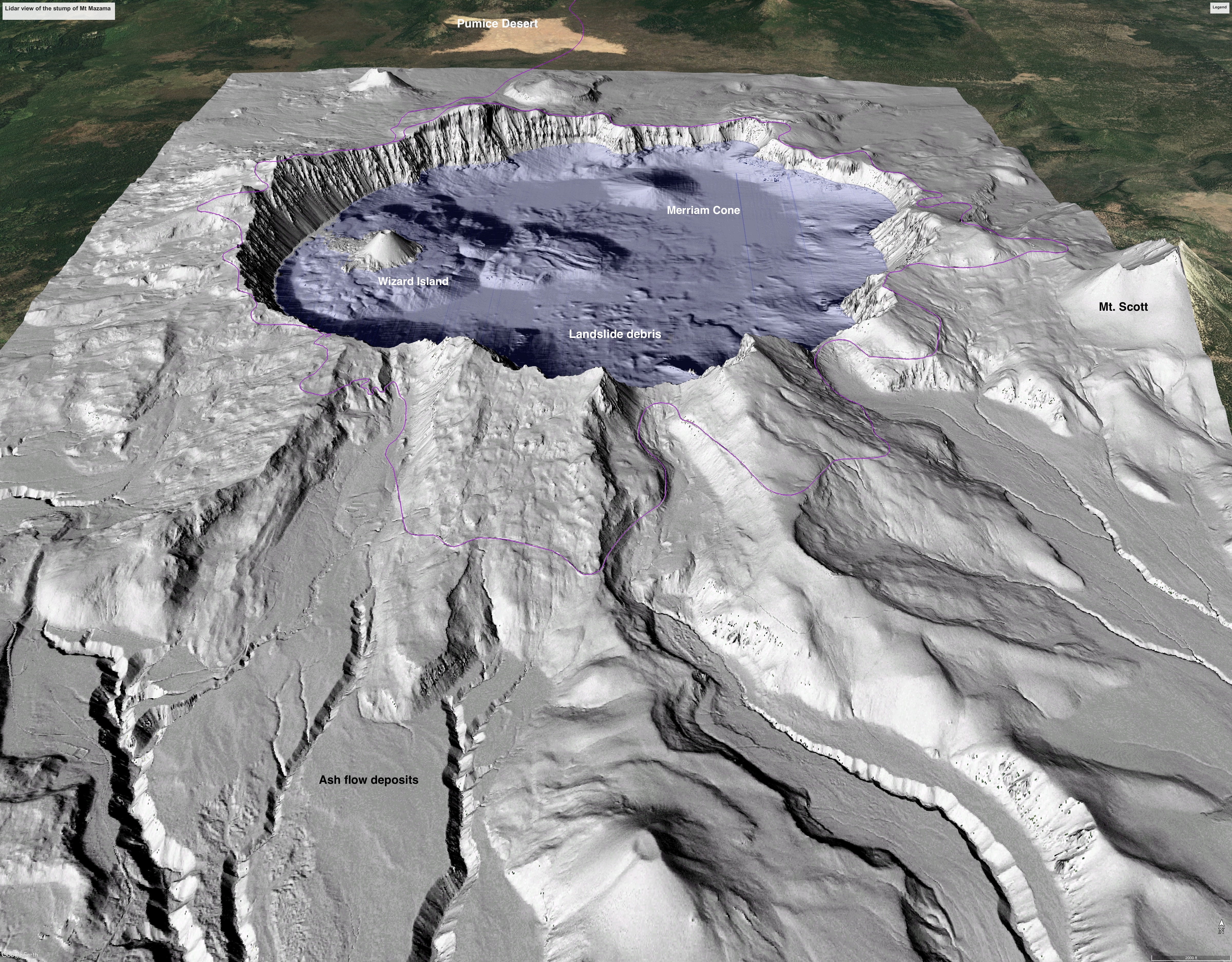
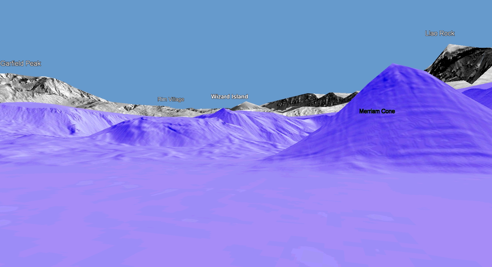
So much magma erupted that the mountain collapsed into the empty magma chamber, leaving a hole nearly 4,000 feet deep. In the years that followed, eruptions from the floor built two small volcanos, Wizard Island and Merriam Cone (Figure 3 and 4). The Wizard Island volcano was actively growing as the lake was filling, with the final eruption occurring when the lake was nearly at its current level. Merriam Cone was built entirely beneath the deep dark water of the nearly 2,000-foot-deep lake.
We start on a long straight and gentle ascent, which will eventually bring us to the Pumice Desert. The eruption column was located at the north end of the volcano, and much of the pumice deposits are thick on this side. Despite abundant rain and snowfall, little grows on the Desert after 7,700 years, because the loose pumice drains easily that surface layers don’t hold enough water to support vegetation. The initial climb ends with the reward of your first view into the crater and the incredibly blue waters of the lake. The lake has filled largely with rain and snow that fall directly into it, rather than water that has run across the landscape, so it is very pure. The lack of nutrients and fine sediment in the water makes for incredible clarity, and gives it its distinctive cobalt blue color.
There are too many cool geologic features on the Rim Drive to cover in this space, and there is tons of interpretive material available online. I suggest you look at:
-
Oregon: A Geologic History, for an overview of Crater Lake’s place in the bigger picture-http://oregongeology.org/sub/publications/IMS/ims-028/unit18.htm
-
The DOGAMI Crater Lake Geologic Guide and Recreation Map which you can download as a pdf for free, or to your smartphone for a nominal charge- http://www.oregongeology.org/pubs/ll/p-craterlake-recmap.htm
-
For the real science geeks, the USGS has a more technical but still very cool map-https://pubs.usgs.gov/sim/3223/sim3223.pdf
Day 6: Clear Water and Big Trees

Leaving camp on Day 6, we ride along the lakeshore and then up to Highway 138 over a small bump of lava that hems in the lake. For the first 12 miles on Highway 138, we descend gently across a wide flat valley. This broad valley is unusual for such mountainous terrain, where steep narrow canyon or glacial valleys are the norm. The valley is flat because we are riding across the top surface of an intracanyon lava flow. About 750,000 years ago, a huge volume of very fluid basalt lava erupted from vents north of Diamond Lake. The lava flowed into the system of canyons that had been carved by the North Umpqua River and its tributaries, and traveled 20-30 miles downstream. So much lava erupted that it filled many of these canyons to a depth of several hundred feet, and in some cases actually flowed back up tributary valleys. When the eruption finally ceased, miles of deep river canyon had been replaced by a barren smoking plain of cooling lava. The rivers that had previously flowed here were left to wander across the flat lava surface before cascading down the snout of the lava flow.

Until Whitehorse falls campground, we are riding on top of the lava surface. Once there we start to descend more steeply, as the canyon cuts down into the intracanyon flow. This point on the river is called a knickpoint, which is essentially a waterfall, cascade or steep stretch of river that is eroding back upstream. This knickpoint started at the downstream end of the lava flow 750,000 years ago, and has been steadily chewing its way upstream ever since.
We descend quickly through the intracanyon flow, which is about 400 feet thick here, and enter into a much narrower canyon, with steep cliffs visible through the trees on either side. Keep an eye out through this stretch for examples of columnar basalt. When thick layers of basalt lava cool slowly, the solid rock breaks into long, generally six-sided columns. These are familiar from famous locations like the Giant’s Causeway in Britain, or Devil’s Tower in Wyoming. You may catch some glimpses of columns in the intracanyon flows as we descend through the flow, or perched high on the canyon wall as we proceed into the older rocks below. Rain and snow that fall on the lava surface quickly disappear into the jointed lava, emerging as springs that feed the North Umpqua. The lava acts as a filter to remove sediment, resulting in the clear waters of the river.

Under the intracanyon flow, the rocks are part of the Western Cascades volcanics. These rocks were formed by volcanic eruptions driven by subduction, producing the same range of lava flows, cinder cones and ashflows as we have already seen along our route. The difference is that these are 30-40 million years old. Time and water have erased all of the original volcanic topography, obscuring the origin of the rocks. We will see outcrops of lava, welded ash, and volcanic mudflows, which look like concrete made with boulders. Although most of the Western Cascade’s rocks are hidden under thick soil or forests, we will see some spectacular crags of lava at mile 33, including Eagle Rock and the Old Man and Old Woman. These spires of resistant rock are probably ancient volcanic plugs, the last thick hard lava that filled the throat of a dying volcano.

When we turn away from the North Umpqua River at Steamboat Creek (world famous for steelhead fishing) we will be preparing to cross over the drainage divide between the Umpqua and Willamette Rivers. This part of the west slope of the Cascades, like most of the range, is managed for timber harvest and although it may not be apparent from the road, we are riding through a patchwork of forest of different ages resulting from a century of clearcutting. Lidar data allows us to rapidly measure and display the height of the trees in the forest, showing the areas of different height trees that result from this history. The height is a good measure of age, and trees in western Oregon typically grow up to 6 feet a year.

The lidar map also shows some remaining areas of old growth forest that has never been logged. In these areas we find huge Douglas Fir trees that are hundreds of years old and among the tallest trees anywhere. The tallest currently known Douglas Fir in Oregon is about 328 ft, or 100 meters. Shortly after we cross the pass between Canton Creek and Sharps Creek, the road will go right through an old-growth remnant. Many of these trees are more that 275 feet tall, and a few close to the road reach as high as 295 feet.
The last miles of our route follows an old railroad grade, and there are numerous exposures of dark grey or black lava, with lighter colored tuff, and rubbly looking volcanic mudflows.
Day 7: Mines & Mysteries

The geology and landscape of Day 7 is largely obscured beneath the blanket of forest that covers the western slopes of the Cascades. Our route on Day 7 goes up the Row River on the Dorena Lake bike path and over the pass into the valley of the Middle Fork of the Willamette river. Along the way, the geology will be a mix of ancient volcanic rocks of the Western Cascades. These rocks have been soaked by millions of years of rains, permeated by caustic hot springs water and buried beneath generations of dense forest. They are generally only visible in stream beds or deep road cuts, and then are often so altered that it is very difficult to determine their origin. As a result, the Day 7 route goes through some of the least known geology in the state. Geologists use a geologic map to describe the geology of an area. Geologic maps show different types of rocks using different colors and symbols, and include lines that show where two rock types come together, or fall lines cut through the rocks. Other symbols show how the rocks are arranged, whether the layers are flat, tilts or folded.

Figure 2 shows the geologic map of our Day 7 route, and the important thing to note is that the entire route only crosses two colors, one depicting volcanic ash and tuff, the other lava flows. This kind of simple geologic map really means that the early geologists in the area (the map was published in the 1960’s) couldn’t make any sense out of the little bits of geology they could see. Geologic maps are constantly being revised and updated, as more sources become available, or new scientific tools, like lidar, become available. This one is long overdue!
As we make our way up Brice Creek towards the pass into the Middle Fork of the Willamette, we will be passing the Bohemia mining district on our right. Starting in the 1860’s, the numerous undergoing mines produced gold, silver, lead, copper and zinc. Today there is little trace left of the mine workings or mining towns that sprang up to support them, they have largely been reclaimed by the forest. One unfortunate legacy is acid mine drainage, which occurs when rainwater reacts with the sulfur-bearing minerals that the mines exposes. The discharge can carry large amounts of toxic metals and impact the health of streams. Modern mines are designed to avoid this kind of long-term environmental impact.
Awesome, I can’t wait to see all of this. If you can recommend a book about the geology of this area that I could read before I come visit that would be great, maybe something similar to “Annals of the Former World”. I’m a flatlander from the craton of Michigan.