Ian Madin has worked as a geologist with the Oregon Department of Geology and Mineral Industries for nearly 30 years. In his spare time he enjoys riding with Cycle Oregon and sharing stories about the incredibly cool geology of Oregon. We are delighted to continue his popular series with two reports from the 2021 Tygh Valley Rally. In a previous post (Geology Rocks – TVR Gravel Forward) Ian gave us a comprehensive look at Tygh Valley and the gravel routes from Weekend #1. Here, Ian takes us along the road routes of Weekend #2

Road Forward – Day 1
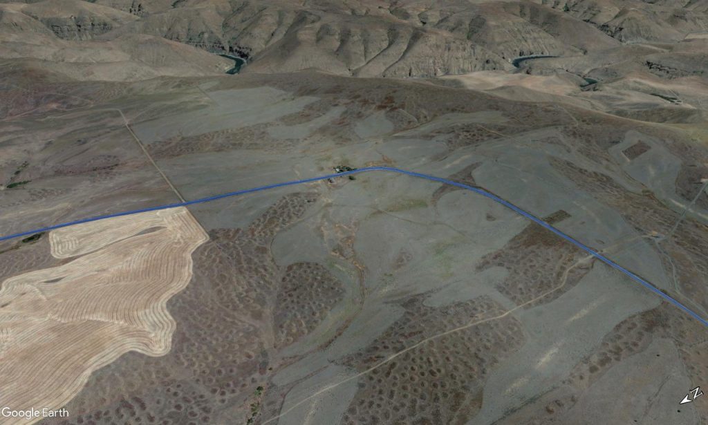
Today starts with a challenging climb through Butler Canyon along Highway 197. One advantage of starting out climbing is that you will be going slow enough to really appreciate the cool geology in the roadcuts; you won’t be looking at the rocks when you come screaming down this hill at the end of the day. We will be climbing across Tygh Ridge, which is a giant kink in the basalt layers of the Columbia River Basalt. Between The Dalles and the northern side of Tygh Ridge, the lava layers slope gently down towards the Columbia River, then at Tygh Ridge they bend sharply down to the south. On the Tygh Valley side of the ridge, the lava layers are tilted steeply towards the south. In the Google Earth image below, you can see where the upturned edges of a steeply tilted lava layer makes a series of upside-down “V” shapes where it intersects ridges.

As we enter Butler Canyon, you should see pronounced stone stripes on the right hand side of the canyon. The stripes extend from the top of the hill to nearly the bottom, and the dark stones stand in stark contrast to the dried grass that makes up most of the slope. Although geologists are still not sure how these features form, they are very common in areas of eastern Washington and Oregon where Columbia River Basalt makes up the local terrain.

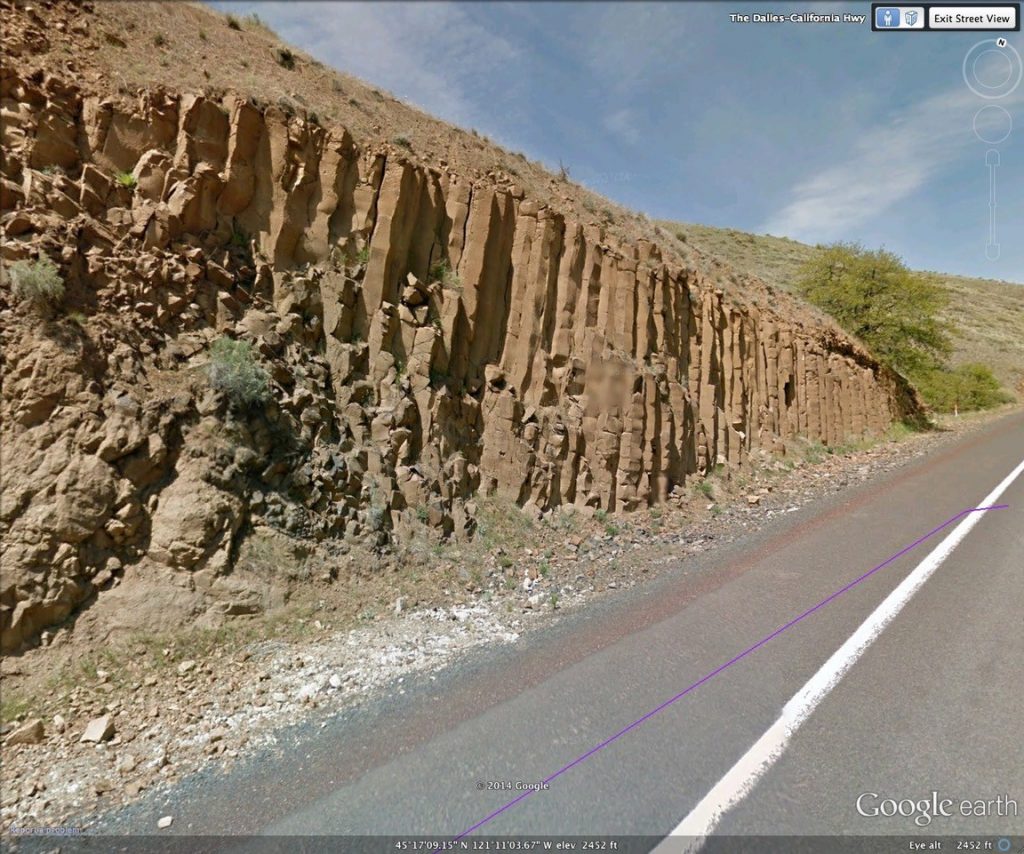
About a third of the way up the canyon, keep a look out for some beautiful basalt columns on the left hand side of the road. Basalt lava solidifies at temperatures a bit below 2000 degrees F, and then the hot, solid lava shrinks as it cools to room temperature, and cracks into these hexagonal columns to accommodate the shrinkage. In some places like the Giant’s Causeway in Britain, or Devil’s Postpile in California, the columns are so regular and perfect that it is hard to believe that they are natural.
A bit beyond the columns, watch for a distinctive light grey rock layer in the roadcut on the left-hand side of the road. This is a layer of sandstone caught in between two lava flows of the Columbia River Basalt. Although most of the Columbia River Basalt flows were erupted in a geologic blink of an eye, there are some places where enough time passed between eruptions that rivers and streams were able to establish courses across the barren lava surface. In this instance, the stream left of layer of white to grey sand, probably brought from the granitic mountains of Idaho to the east.

As we near to the top of the climb, watch for basalt pillows in the roadcut on the left side of the road. Basalt pillows form when basalt lava flows enter deep water. The lava freezes solid when it hits the water, until the pressure of the liquid flow cracks the frozen surface and a glob of liquid lava squirts out like toothpaste from a tube, then instantly freezes in the water. The lava flow advances by building a pile of these long tubular lava pillows. In the road cut , you will see rounded bodies of dark lava in a yellow-grey mass of clay-like material.
We turn west at the top of the climb and begin to ride up a broad plateau gently rising towards Mt Hood. This is the apron of volcanic sediments and young lava flows of the Dalles Formation, and the ride will be across the rocks for most of the day. Don’t expect to see much in the way of rock until you get back to Dufur where you will once again see Columbia River Basalt.
When you have ridden back down Butler Canyon and found your shower and lawn chair, have a look across the valley to Tygh Ridge, and see if you can spot the inverted “v”s formed by the tilted layers of rock.
Road Forward -Day 2
Our route today starts with an easy climb out of the canyon and on to Juniper Flat. Here, the broad apron of the Dalles Formation is capped by the Juniper Flat lava flow, which spread down the slope from the High Cascades six million years ago. Once you are on the flat there aren’t many rocks to see, but you will pass by some mysterious features on the landscape that still baffle geologists. The ground here is covered with a thin layer of wind-blown silt called loess. The loess originated as rock ground to fine flour beneath the glacier that covered the northern hemisphere during the last ice age. The fine rock dust was flushed down the Columbia River and then picked up by the wind and blown across the landscape. Here it is only a few feet thick, but supports the drylands wheat farming that is an economic engine for the area. Where the natural surface is preserved between the fields you may see Mima mounds if you look carefully. Mima mounds are regularly spaced, circular mounds of loess a foot or two high and 10-20 feet across. They stud the eastern Oregon landscape in many areas where the natural ground surface has not been disturbed. Geologists still argue about the cause, but one currently popular theory suggests that long-lived colonies of burrowing rodents slowly build the mounds. You may be able to see mounds from the road (there are some on the left just as you first come up onto the plateau) but they are much easier to see from the air, and even easier to see using a laser topographic scanning system called lidar.
As you drop into Maupin, the canyon of the Deschutes River has cut deep into the dark layers of Columbia River Basalt. The flows are typically 50 to 150 feet thick, and are generally loose and rubbly at the top, and dense and hard in the middle. This difference in the strength of the rock makes for a characteristic cliff and bench landscape, similar to the iconic geology of the Grand Canyon. The difference is that the sandstone and limestone layers of the Grand Canyon were each laid down over millions of years by gradual accumulation of sediment, but the each layer of Columbia River Basalt was deposited in a matter of days to weeks. The ride down the canyon ends when we cross the river at Sherars Bridge, where a spectacular series of falls has developed as the river struggles to erode through a particularly hard layer of basalt.

Leaving the Deschutes we wrap up the day with a stop at the White River Falls. There is a really cool story behind these falls. The plateau to the south of the White River here is capped by the Juniper Flat lava flow, and underneath it are soft sand and clay of the Dalles Formation. Thousands of years ago, the river flowed farther south, and undermined the slope beneath the heavy lava cap, causing two huge landslides (Figure below) to take arc-shaped bites out of the lava plateau and block the White River. A lake built up behind the landslide dam, rising until it found a new path down a steep slope into the lower canyon. The water running down the slope quickly became a waterfall, and the falls has since migrated upstream a half a mile, as the force of the falling water chews away at the basalt.
